A glaring bright screen of my laptop is the last thing I see each night. With a soft thud, it closes, reaching “sleep” before I shut my own eyes. Upon morning’s arrival, I open it again to be greeted by the same glare.
First stop online: Kyodo news.
20km is the maximum government evacuation radius around the Fukushima reactors, with some foreign embassies recommending 80. Fortunately, a generally South-Western wind has helped blow much of the contamination seaward. Until this morning.
8am. Weather authorities forecasted unusual reversal in wind direction, suddenly placing my city exactly 170km downwind. Panicking, I scrambled to find data that might signal any rise radiation levels.
I needed to warn my parents.
As a planned city, Tsukuba forms an amalgamation of nearly 300 research institutes, both public and private.
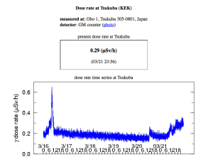
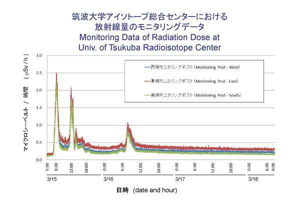
Sure enough, if it wasn’t University of Tsukuba’s Radioisotope Center or the National Institute of Advanced Industrial Science & Technology, then there was the High Energy Acceleration Research Organization’s real-time γ dose monitor that published data from their radiation monitoring stations.
Morning levels were nearing 0.2μSv/h when I contacted my parents. They have since reached 0.29μSv/h as of midnight, roughly 3.5 times the natural range (0.07-0.09μSv/h).
I do hope the winds change soon.
* * *
Historical data shows the highest spike reaching 2.5μSv/h on March 15th, when explosions occurred Unit 2 while fire broke out at Unit 4 of Fukushima I.


